As of October 31, 2012, the Pequea Boat Launch dredging project was suppose to be completed. That was over 8 weeks of work project to improve the launch area. Then Hurricane Sandy came up the Atlantic coastline and hit the area on Monday, October 29th leaving 3 to 6 inches of rain in the Lower Susquehanna River Valley. Jeff contacted me to say that Safe Harbor had reported that there was 13" rainfall in a 24 hour period during the storm. I tend to follow WGAL Weather which reports from Harrisburg, Pa which was further west than where we live here in Willow Street, Lancaster County, Pa.
Small streams, like the Pequea Creek, flooded and reeked havoc along their shorelines, including the Pequea Boat Launch. The boat launch lies at the mouth of the Pequea Creek and the Lower Susquehanna River.
I hadn't heard any news regarding the completion of the dredging project prior to the storm. So this morning, my wife and I took a drive to Pequea, Pa. to see what progress has been made.
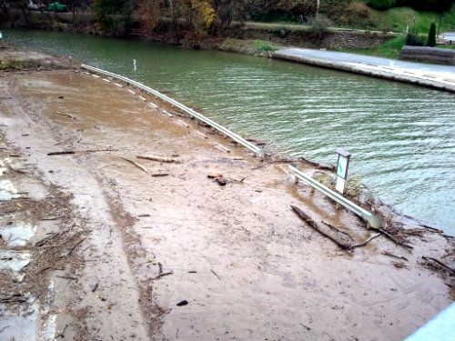
What we noticed was that the gate was still locked and the "No Trespassing" signs were still in place stating that "October 31, 2012" was the target date (five days ago) to reopen. The one dredging boat and two smaller aluminum jon boats and their equipment were no longer in the creek or parking lot area. The courtesy docks where the boats were moored had been removed and were sitting on a strip of grass across the street from the launch area. They were removed in time to prevent any damage from the flooding that came with Hurricane Sandy.
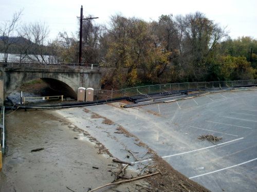
There was still a lot of plastic piping sitting along the edges of the parking spaces by the railroad tracks and the orange fencing was still in place at the pit where the dredging material (mud and water) was being dumped and stored.
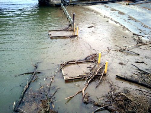
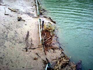
Below are several pictures from today's visit to the PPL Pequea Boating Launch.
PPL Pequea Boat Launch Parking Lot By The Norfolk Southern RR Tracks (Susquehanna River Side)

PPL Pequea Boat Launch Muddy Ramps With Debris

Courtesy Dock Parking Lot (Opposite Side from Ramps)

Courtesy Dock Area Along The Pequea Creek

As you can plainly see, PPL will need to bring in a front end loader to scrape the mud off the parking lot and to pick up the debris left behind by the rising waters of the Pequea Creek.
Lake Aldred (Lake b/w Safe Harbor and Holtwood Dams) was quite high today. Spill at the Holtwood Dam begins at 169.75'. Today's level at Lake Aldred was 172.7' when we arrived which is three feet above spillage level. That's a heck of a lot of water in a section of river that runs approximately 7 miles in length!
Fishing In The Fog (Continued) - October 24, 2012
Several blog entries ago, I had posted several pictures of a very foggy morning on the Susquehanna River with Jeff (CHRGD). It was a slow ride to get to our first fishing hole. I tried to get my smartphone's GPS up and running, but it wasn't updated and I had difficulty getting the app to function (It's now working!). Needless to say, we eventually made it to our spot with the help of a good 'ole fashion handheld compass!
Check out the view we had from the boat as we were heading downriver to our first fishing hole...
I think we went around in circles three times and kept seeing our own wake... LOL! Jeff said something to the effect of, "We went around in circles three times and passed ourselves twice." :)
As you can see by the video, a GPS or compass with common sense will get you where you want to go in the fog. If you lose your bearings, turn your "big motor" off and listen for common noises like cars or trucks driving on roadways and bridges or birds chirping in trees from along the shorelines.
I remember one Lancaster County Hawg Hunter's club tournament back in the 1990s that we launched from the Susquehannock Park in Maryland. This launch is across the river from Port Deposit, Md. I had a 1980 Sketter bass boat with a 150 Johnson GT at that time and a launch pass for the Port Deposit Boat Launch. It was the very first year that the city required the permits to launch at the park.
I also owned one of the first handheld Lowrance GPS systems. I had fished at Port Deposit several days earlier to pre-fish and see what was happening on the "Flats". I had placed several waypoints (reference points) into the GPS (Port Deposit, Havre De Grace, etc), but failed to waypoint the Susquehannock Park... Duh!
The morning of the club tournament came and my rider and I launched from Port Deposit and used the compass on my Lowrance GPS to guide us across the river to the Susquehannock Park where our club was meeting. Well, we got about three quarters across the river and I knew we were closing in on the park, but we couldn't see a darn thing! So, we shut down the big motor down and just listened. Within a few seconds, we heard the start up of boat motors at the Susquehannock Park launch. We then "putzed" towards the sounds of the motors and eventually saw the huge parking lot lights in front of us... Yea! We made it safely.
Once at the parking lot, I placed a waypoint for the Susquehannock Park into my GPS... Finally!
The tournament director made the decision to launch in the fog. So with our running lights on and a good GPS route entered into the handheld Lowrance, we headed directly back to the Port Deposit launch where I knew there were several 4 lbers just waiting for us... Oh yeah!
A day that could have been a disaster ended up being saved by the use of a good GPS and a little common sense.
Take Care and Be Safe!
Dad
